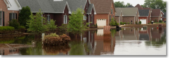
Floodplain
The Federal Emergency Management Agency (FEMA) defines a flood zone as two or more acres of normally dry land or two or more properties which are temporarily covered by water or mudflow caused by hurricane or high-tide surges, overtopped creeks/ rivers/ levees, undersized or clogged drainage systems, or ponding rainfall. FEMA collects statistical data for river flow, storm tides, hydrologic/ hydraulic analyses, and rainfall and topographic surveys to create Flood Insurance Rate Maps (FIRMs). FIRMs show risk Zones for flooding. Special Flood Hazard Area Zones A/ AE/ AH/ AO/ A99 (100 year flood) and V (coastal waves and storm surge) have a 25% chance or higher of flooding during a 30-year mortgage. Buildings in SFHA Zones with federally-back mortgages must have flood insurance (National Flood Insurance Program). Mortgaged buildings in moderate-risk Zones B and C and minimal-risk Zone X (500 year flood) are not required to have flood insurance. Digital copies of FIRMs throughout the nation are available on-line to view at the FEMA Map Service Center.
Check with your jurisdiction or FEMA for your Floodplain Administrator’s contact information.
Flood Map Revisions
FEMA has been updating its FIRM data base nationwide for several years. These maps are not property specific (e.g., no lot boundaries) and use topography features and infrastructure indicators which are visible from satellite photographs for reference. Consequently, the accuracy for the locations of properties within specific Risk Zones is not in all cases infallible. Owners who have had flood insurance may suddenly receive notification from their lenders that they must buy flood insurance. If an owner wishes to dispute either the location of their property within a SFHA Zone or the elevation of their property below the Base Flood Elevation (“high-water mark”), they may apply for a Letter of Map Amendment (LOMA) or a Letter of Map Revision Based on Fill (LOMR-F). The owner must bear the cost for obtaining specific information which substantiates their application (e.g., property elevation survey). Approval of a LOMA or LOMR-F is confirmation that flood insurance is not required.
Construction In A Floodway
A Floodway is the channel of a river, creek, or other watercourse and the adjacent floodplain. Because new building construction, substantial improvements, and earth fill within a Floodway will impede the flow of floodwater, the obstruction must be designed so it will not increase the upstream high-water elevation above a pre-established Base Flood Elevation (BFE). A FEMA permit for a Floodway Encroachment is required for construction in SFHA Zones, and the lowest floor (including basement) must be built above a BFE. Fill is not allowed in Zone V. If your jurisdiction has established a Flood Hazard Area and a BFE, Flood Resistant Construction is required.
Check the Links below and contact your local Floodplain Administrator for additional information.
Links
BUILDING in CALIFORNIA
- Forums – Blog
California Building Standards Code
Federal Emergency Management Agency
Flood Smart
California Office of Emergency Services